Tag Archives: U.S. Army Corps of Engineers

Lake Okeechobee/Kissimmee Chain of Lakes Update

March 2025 FloridAgriculture eNewsletter

Lake Okeechobee recession is continuing due to Recovery Operations, as well as increasing evapotranspiration and water supply deliveries.

As of February 17th, 2025, the lake stage is 14.04 feet, which is down 0.14 feet over the last week, and 0.56 feet over the last month. The U.S. Army Corps of Engineers (Corps) and the South Florida Water Management District (District) are maintaining Lake Okeechobee System Operating Manual (LOSOM) Recovery Operations where LOSOM release guidance is up to 2,100 cubic feet per second (cfs) at the S-79 structure west into the Caloosahatchee River, 1,400 cfs total east to the St. Lucie River, and max practical releases to increase flow to the south.

Average flows for the last week from Lake Okeechobee to the east and west have averaged 500 and 1,500 cfs, respectively, towards the downstream targets with 1,300 cfs going to the Everglades Agricultural Area (EAA) for water supply, and 1,400 cfs to the stormwater treatment areas (STAs). The lake stage is currently in Zone D2 (see graphic below), where LOSOM guidance without recovery operations being implemented would be up to 750 cfs at S-79 and zero east to the St. Lucie with maximum beneficial flows south.

Discharges made south from the Upper Kissimmee Lakes are being made to reach the June 1st low pool targets. Lake Kissimmee is below schedule with decreasing releases to the river channel.
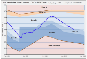
Figure 1. Lake Okeechobee stage as of 17 February 2025.

The Stormwater Treatment Areas (STAs) are exclusively treating water from Lake Okeechobee. The latest 28-day STA inflow concentrations in the Eastern Restoration Strategies flow path range from 158 to 191 parts per billion (ppb) of phosphorus, with outflows from the STAs ranging from 18 to 26 ppb. Inflow concentrations in the Central flow path range from 83 to 101 ppb, with outflows ranging from 12 t0 17 ppb. The Western flow path, STA 5/6, has had no inflow for the last several months.

Most STA cells, or sections within the whole STA, are near their target stages, but many flow ways still have stressed vegetation conditions. There are operational restrictions in place for most of the STAs for vegetation management and/or construction activities.

Water Conservation Area (WCA) stages are decreasing, and some northern areas have water near ground surface (see depth graphic below). WCA-1 is at and receding with its schedule with no outflows to WCA-2A or to tide. WCA-2A is 0.97 feet above schedule with only water supply deliveries being made to Broward County. WCA-3A is 0.80 feet below schedule with large areas in the south below historical averages, but still above ground surface.

Everglades National Park is continuing to receive water into the dry season based on Tamiami Trail Flow Formula (TTFF) targets. WCA-3A is below schedule and the TTFF calls for 981 cfs from WCA-3A. The S-12C and S-12D structures and the S-333 structures are open and delivering 986 cfs into the park. Hydrologic connectivity within Shark River and Taylor Sloughs has diminished over the past two months, however, depths remain conducive for water flow. The S-356 structure is off, with diminished seepage and lower canal stages. The S-332D and S-200 are pumping water into the detention areas as needed to control South Dade canal stages. The gate from the Frog Pond detention area into Taylor Slough is open. Florida Bay flow and salinity metrics remain well outside of all harm thresholds.
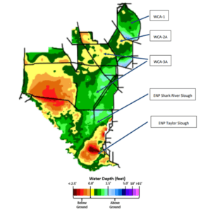
Figure 2. Water Conservation Area water levels as of 17 February 2025.
Lake Okeechobee Enters Recovery Mode

January 2025 FloridAgriculture eNewsletter

The U.S. Army Corps of Engineers (USACE) began releases under Lake Okeechobee Recovery Operations on December 7, 2024.

For the past five years, Lake Okeechobee has experienced several storm events and extended moderately high lake stages. This has led to degraded ecological conditions within the lake, including significant loss of submerged aquatic vegetation (SAV), high turbidity and nutrient concentrations, and negative changes in emergent vegetation.
There are six considerations for implementing Recovery Operations – lake stage not receding below 13 feet in summer, SAV coverage significantly below 11,000 acres, no strong El Nino, nor strong La Niña forecasted for the dry season, lake stage not receding below 11 feet NGVD in the last five years, ecological and Snail Kite conditions, and no water supply concerns. Each of these six of the considerations have been met, and current projections show that conditions this dry season are favorable for success.

The goal of recovery is to lower lake levels before the onset of the wet season to allow for recovery of lake ecology, specifically SAV. The operational strategy for these operations intends to slowly bring water levels down by making moderate, non-harmful releases to the estuaries while also sending maximum beneficial flow south to the Everglades. Lowering water levels will allow light to penetrate to the bottom and allow SAV to regerminate and regrow during the April-July period. Regrowth of SAV in Lake Okeechobee will reduce water turbidity and nutrient concentrations. Improved water quality within the lake benefits the estuaries if significant releases are necessary in the coming seasons/years.

Consistent with the Lake Okeechobee System Operating Manual (LOSOM), the maximum allowable releases under Recovery Operations are:

  • up to 2,100 cfs at S-79 to the Caloosahatchee River Estuary (CRE)
  • up to 1,400 cfs total St. Lucie Estuary (SLE) inflows (S-80 + S-97 + S-49 + Gordy Road)
  • up to 300 cfs to the Lake Worth Lagoon (LWL) at S-271 and S-352
  • up to maximum practicable south at S-351 and S-354

Releases will be made in the most beneficial way possible. USACE will continue to collaborate with South Florida Water Management District (SFWMD) and other partners to evaluate flow and salinity to inform estuary releases on a weekly basis. Depending on conditions, releases will either be made as a pulse, or a constant flow targeted at S-80 and S-79. The releases allowed under Recovery Operations are within the RECOVER optimal flow envelope for the estuaries and will not impact oyster spawn, sea grass, spawning, or other ecological activities.

Flow south from the lake has started to increase significantly, as water supply demand has picked up early in this dry season. Flow south to the Everglades will occur based upon capacity of the state’s Stormwater Treatment Areas (STA’s) and the capacity of the Water Conservation Areas (WCA’s) to the south. The capacity of those will generally increase as we move through the dry season.

Exactly when and how much to release within limits will be based on the considerations including, but not limited to, coordination with stakeholders and partner agencies, current and historical lake levels, recession rates, climate outlooks, El Niño-Southern Oscillation (ENSO) forecasts, precipitation forecasts, drought conditions, water-supply conditions, and nesting activities and ecological conditions in the lake, Northern Estuaries, and the Greater Everglades. USACE is constantly monitoring the entire system, and the recovery releases and strategy can be discontinued at any time throughout the dry season if warranted.

South Florida Water Management District Vertical Datum Upgrade

July 2024 FloridAgriculture eNewsletter

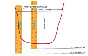
To enhance the accuracy of their data, the South Florida Water Management District (SFWMD) is upgrading the reference system used to measure water elevations in our monitoring network. SFWMD is currently in the process of shifting from reporting water elevations in the National Geodetic Vertical Datum of 1929 (NGVD 29) to the North American Vertical Datum of 1988 (NAVD 88). This includes data within the SFWMD’s environmental database for hydrologic, meteorologic, hydrogeologic and water quality data. 

The upgrade will provide the public and stakeholders with more accurate information about levels for waterbodies in the region. 

Depending on the location within the SFWMD, water levels in the newer NAVD 88 measurement system will be about 0.6 feet to 1.6 feet lower than in the older NGVD 29 measurement system. 

For example, the difference between the two measuring standards in Lake Okeechobee is 1.25 feet, so a water level of 11.25 feet NAVD 88 is 12.5 feet NGVD 29. 

Water elevations are reported as the height of the water surface compared to sea level. Water depth, on the other hand, is the height of the water surface as measured from the bottom of the water body. When NAVD 88 is fully implemented in 2024, water measurements will be published exclusively in NAVD 88. 

As of now, the U.S. Army Corps of Engineers has not stated that they will be transitioning as well, so for the time being, water levels will have to be reviewed through two different reference systems. 

New Regulation Schedule for Lake Okeechobee Announced

July 2024 FloridAgriculture eNewsletter

Pursuant to the National Environmental Policy Act (NEPA), the U.S. Army Corps of Engineers, Jacksonville District (USACE) has issued a Notice of Availability for the Lake Okeechobee System Operating Manual (LOSOM) Final Environmental Impact Statement (EIS). USACE is proposing a new regulation schedule for Lake Okeechobee within an updated Water Control Plan (WCP).

The regulation schedule is a compilation of operating criteria, guidelines, and figures that govern the quantity, timing, and duration of releases out of the lake. The regulation schedule establishes the agency’s operational strategy to balance the congressionally authorized project purposes for flood risk management, water supply, enhancement of fish and wildlife, navigation, and recreation. Implementation of this regulation schedule corresponds with the completion of the Herbert Hoover Dike (HHD) rehabilitation and considers completed or nearly completed Comprehensive Everglades Restoration Plan projects. LOSOM is intended to replace the current Lake Okeechobee Regulation Schedule, known as the 2008 LORS (LORS08).  

Florida Farm Bureau Concerns Revolve Around Four Topics: 

  1. The State’s ability to meet water supply needs under LOSOM 
  1. The unprecedented flexibility in LOSOM’s operation plan may cause impact outside of those identified through the NEPA process 
  1. The proposed plan’s modeling results produce EAA irrigation water demand volumes substantially less than volumes in the real-world data set 
  1. LOSOM does not include a water conservation or beneficial use zone above the Water Shortage Management (WSM) Zone that would reduce the risk of entering the WSM Zone. Clear and concise deference is not given to the SFWMD prior to water shortage 

The Corps has stated they will review comments, address concerns, update minor changes, and are very set on a Record of Decision scheduled on August 12, 2024. Florida Farm Bureau submitted comments that can be read here.  

Federal Judge Vacates Florida’s 404 Permitting Authority

May 2024 FloridAgriculture e-Newsletter

On February 15, 2024, the U.S. District Court for the District of Columbia issued an order that nullified the U.S. Environmental Protection Agency’s (EPA) approval of Florida’s application to take over permitting authority from the U.S. Army Corps of Engineers (USACE) under Section 404 of the Clean Water Act (CWA) within the state. The court’s decision was based on allegations that the federal defendants violated the Administrative Procedure Act (APA) and the Endangered Species Act (ESA) during the approval process, which occurred in the final days of the Trump administration.

Under the ESA, any action that might harm endangered species requires consultation with the U.S. Fish and Wildlife Service (FWS) to ensure the action does not jeopardize the species’ existence. When Florida assumed the 404-permitting program, there was no clear process for ESA consultation. To address this, the EPA and FWS conducted a programmatic consultation resulting in a biological opinion (BiOp) and incidental take statement (ITS) meant to protect future permittees from ESA liability.

However, the court found this process deficient, particularly because it lacked species-specific analysis and numerical take limits as well as determined that the technical assistance process proposed by the defendants was not a lawful substitute for ESA procedures. Consequently, the court ordered the vacating of EPA’s approval of Florida’s assumption application, effectively reverting permitting authority to USACE until further resolution.

The ruling would affect pending and future permits, significantly impacting Florida’s environmental regulation landscape. The court acknowledged potential disruption but emphasized the importance of complying with ESA requirements. It was uncertain how state and federal agencies would respond, but the decision underscores the complexity and sensitivity of environmental permitting processes, especially concerning endangered species protection.

On February 26, shortly after the Court ruled to vacate Florida’s permitting authority, the Florida Department of Environmental Protection (FDEP) filed a motion for a partial stay, which would allow for the state to process the 1,500 permits without an ESA designation. Of those permits, around 90% would be allowed if the stay was granted and could move forward through FDEP. The preceding judge called for a conference regarding the issue on April 4th in Washington D.C., and on April 12th, Judge Randolph Moss issued an order to deny FDEP’s motion for a stay. As a result, Florida quickly launched an appeal to challenge the decision by U.S. District Judge Moss at the U.S. Circuit Court of Appeals for the District of Columbia. It is uncertain whether FDEP will regain authority to issue 404 permits again, but in the meantime, all pending and future 404 permits will be processed by USACE.